Use APKPure App
Get コンパスEX/登山届GPS地図アプリ old version APK for Android
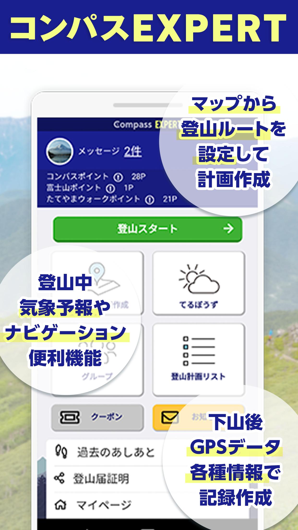
The Compass EX app is a mountain climbing map app that allows you to enjoy mountain climbing safely and with peace of mind, allowing you to submit mountain climbing notifications in mountain areas nationwide, and check your current location with GPS even when you are out of communication range.
The Compass EX app is a comprehensive mountain climbing map app that allows you to enjoy mountain climbing safely and with peace of mind, allowing you to submit mountain climbing notifications for mountain ranges across the country and checking your current GPS location while climbing even if you are out of communication range.
・Mountain and Nature Network Compass allows you to share mountain climbing plans created from the website (https://www.mt-compass.com/) or the EX app with family and friends, and after climbing, sends a descent notification to the person you shared the mountain with. We have created the habit of mountain climbing and provide it as a standard mountain climbing notification system.
・In case of an emergency, we cooperate with the police and local governments through a network, so when an accident or distress occurs, we can quickly make an initial response and assist in rescue and search efforts.
[Compass EX is a safety tool for climbers]
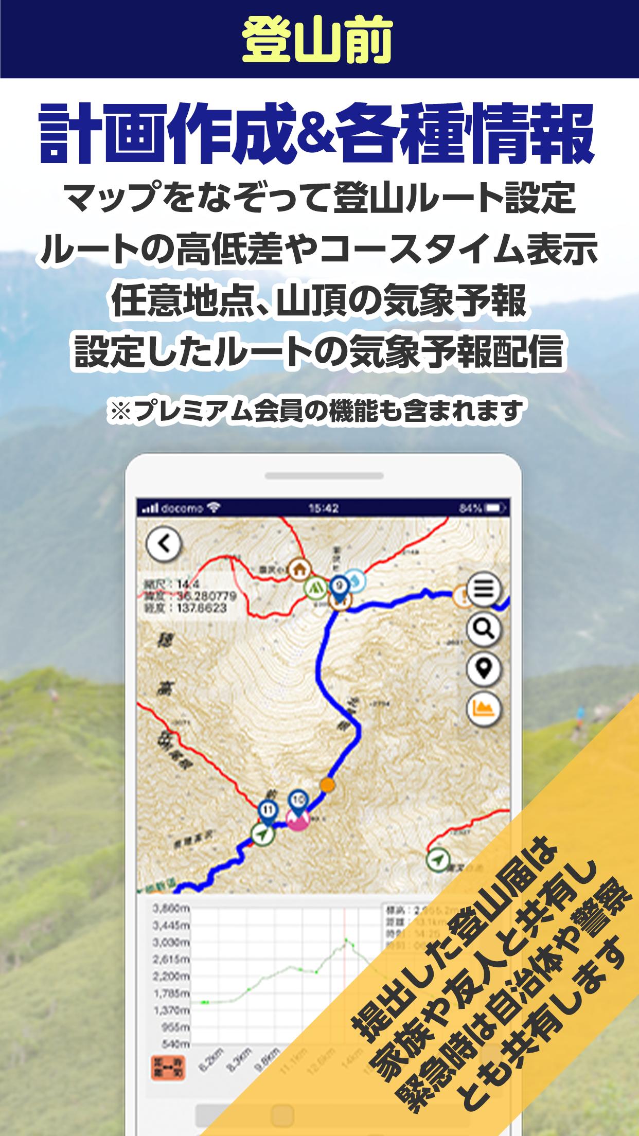
●The app allows you to plan your mountain climbing route using the Geospatial Information Authority of Japan map using the following methods.
・As a recommendation for beginners, if you tap the icon of the mountain peak you plan to climb, recommended courses will be displayed, so please select a round-trip climbing route and create a plan.
- If you want to create a plan from a general mountain climbing route, please specify the mountain climbing course by tapping the entry point, stopover point, and descent point of the mountain climbing route in sequence, or by tracing the route on the map with your finger.
- For mountain climbing where the route is not displayed, such as variation or mountain climbing, you can specify your own route by tracing the map with your finger.
・You can download the map of the mountain climbing route you have submitted to the app without any restrictions before climbing.
・While climbing, you can check your current GPS location using the downloaded route map even in mountain areas that are out of communication range, and you can share this location information with your family and friends.
*The web map of the app will not be displayed outside the communication range. We recommend downloading the map in an environment such as Wi-Fi before climbing the mountain.
●Additional functions linked to the map
・Display the distance and height difference of the planned route in a graph.
・Displays reference walking time from start to finish.
・Walking reference time can be adjusted +/- according to your leg strength.
- "My Time" walking time function that calculates based on past log records.
- Check the weather forecast (weather, wind direction, force, temperature) for one week ahead in any mountain area in the country.
・Obtain weather forecasts by email according to the schedule of your submitted mountain climbing plan.
・Displays the times and directions of twilight, sunrise and sunset, and twilight anywhere in the mountain areas of the country.
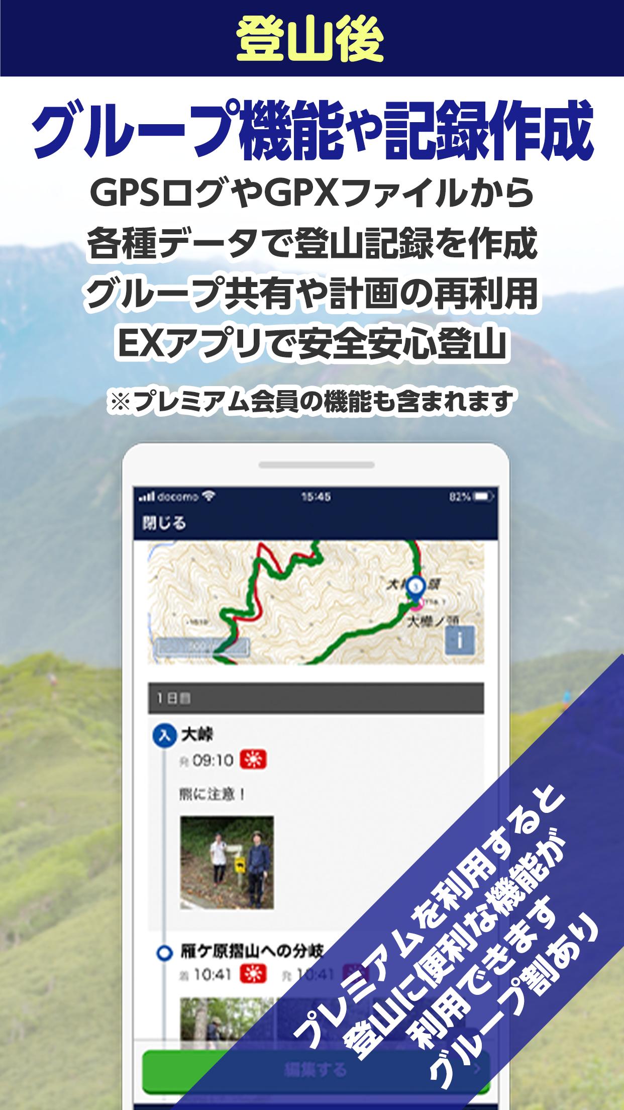
●Climbing record editing function
・Edit the GPS walking log obtained during mountain climbing as a mountain climbing record.
- Add photos and text after climbing and save as a climbing record.
・Can be shared with companions or groups
・You can also import the weather during your climbing trip into your climbing record.
●You can share it with your family, friends, mountaineering circles, mountaineering groups, etc.
- When creating a mountain climbing plan, you can share it with family, friends, or groups.
・The "Companion Plus!" function allows companions who have submitted a climbing registration to synchronize their EX app with their plans, registering their own emergency contact person, and using the app's additional functions in the same way as the person submitting the climbing registration. This is a function that you can use. We do not share your personal privacy with others.
・The "Group" function is a function that allows you to create a group with a mountaineering club or mountaineering club and share mountain climbing notifications with your friends. Administrators can centrally manage group mountain climbing reports.
・The "Imakoko" function allows you to send location information and a standard message to family and friends specified when creating a mountain climbing notification. Data transmission may be possible even in weak radio wave bands where calls cannot be made.
・The "Footprint" function allows you to check consecutive footprints while climbing on a map. In areas where the climber is out of communication range, the last point where communication was possible will be displayed, and once the climber enters the communication area, the display will continue automatically.
● Compass mountain climbing data user return
・The "Analyzer" function returns the data collected by the Compass mountain climbing system to the user as information for the next mountain climbing.
・Display of climbers' footprints on national mountain climbing routes by year and season
・Climbing route and mountain congestion status up to one week in advance
・Displays the acquisition status of communication radio waves along the mountain climbing route, divided by communication company.
・Climber accident cases and climbing route information
●Joint operation with Japanese mountaineering organization
・Compass is operated jointly with the Mountain Safety Measures Network Council, which is operated by four Japanese mountaineering organizations.
・Japan Mountaineering Association
Japan Mountain and Sport Climbing Association
Japan Labor Mountaineering Federation
Japan Mountain Guide Association
Mountain and nature network compass
・Please check the URL below for details.
https://www.mt-compass.com/anzentaisaku.php
[For use]
・You can use the Compass "app" and "web page" services with one account (ID: password).
・Some features of Compass include premium services. Please check the URL below for details on the app's functions.
https://www.mt-compass.com/ex_info.php
・Before using the app, please check your smartphone's GPS settings, low power mode settings, etc. according to the URL below.
https://www.mt-compass.com/uses001.php
・Privacy-related settings such as GPS location information and email reception may be reset when updating the smartphone's OS or if the app has not been used for a long time.
・In some municipalities, the method of submitting mountain climbing notifications may differ depending on ordinances and guidelines. Please submit according to the requirements displayed or instructed on the map in the compass or when creating the mountain climbing notification.
[Terms of Use/Privacy Policy]
・Please see the terms of use and privacy policy for the Mountain and Nature Network Compass app/services below.
·terms of service
https://www.mt-compass.com/rules.php
·privacy policy
https://www.mt-compass.com/privacy.php
Last updated on Jun 8, 2024
・一部のおすすめルートで発生する不具合に対応。
・端末の表示サイズを変更した場合にナビ画面が崩れる問題に対処しました。
Latest Version
![]() 1.7.3
1.7.3
Uploaded by
Uweyy Oi Oi Oi
Requires Android
Android 6.0+
Available on
![]()
Category
Report

Discover what you want easier, faster and safer.

コンパスEX/登山届GPS地図アプリ
1.7.3 by INFCAM CORPORATION
Jun 9, 2024